Monti della Laga Itineraries
Padula’s Loop
| Cartografia | |||||||||||||||||||||||
|
|||||||||||||||||||||||
|
Insert a start address and click to Search button
|
|||||||||||||||||||||||
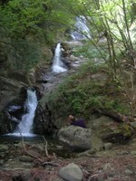
The excursion starts from the town center of Padula (932 mt.) in the township of Cortino, immersed in the green forests of the Laga Mountains. You must first reach the old mill and then, follow the Sentiero Italia path along the direction of Ceppo and reach the Flammagno bridge, where it’s possible to see a rich re-population of Yew trees. A short detour can bring you to the Cantagalli Falls, three consecutive falls with which the Fosso della Cavata flows into the Tordino river.
Once you reach the Macere clearing (1140 mt.), you cross the Fosso della Cavata on a small iron bridge and follow an easy path towards Padula, with a panoramic view of the high Tordino valley.


