Monti della Laga Itineraries
From Cesacastina to La Valle delle Cento Fonti
| Cartografia | |||||||||||||||||||||
|
|||||||||||||||||||||
From Cesacastina you follow the road that climbs up to Colle della Pietra until Piane, pass a sport field, turn left and soon after you’ll reach the bridge of “Fosso dell’Acero” and park your vehicle (1320 mt.)
From this point you can reach Cesacastina directly on foot by taking, west of the village, the path that passes an ancient fountain, (1157 mt, no name path on the I.G.M. map), flanks the “Fosso dell’Acero” on the right and then joins a road that continues 300 meters on the left. On the right a short chain road brings you to an Enel refuge.
Climb up a path that crosses a small grassy valley. Uphill it bends to the right crossing fields and enters a forest, crossing right away a small grassy pit on the right. Keep between the knoll that you just crossed and the Fosso dell’Acero and you’ll gradually leave the area and reach a dirt road that becomes a winding road.
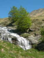
Follow a wide path on the right that will bring you to a clearing facing a waterfall. You can continue on, following the torrent, parallel to a long rock bed on which the torrent water flows and exit the forest, after crossing a stream on the right.
Walking through grassy hills you can reach a second waterfall and, above, once you crossed a dirt road coming from the right, you reach Sorgente Mercurio (1800 mt.)
You can climb freely in the wide “Valle delle Cento Fonti”, marked by crevices and go in the direction of the Sella di Gorzano. In this way you reach the head of the valley, the Cento Fonti, where it bends decisively to the left (west) and reaches the highest peak of the Laghetta (2372 mt.)


