Valle Siciliana TRail
|
|||||||||||||||||||
|
Inserisci l'indirizzo di partenza e clicca sul pulsante Cerca
|
|||||||||||||||||||
From the newspaper shop little square in Isola del Gran Sasso you pass through the village moving towards the crossroad with the road that leads to Casale San Nicola, than you turn right and walk 1 km on the asphalt until you find a concrete bridge on your left that enters the countryside. Here starts the real trail: you follow a dirty rock track that passes by the ruins of San Valentino and reaches after a steep climb the middle of Cerchiara village.
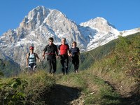
Pass under the highway piers and climb up to the village houses. Behind the church of Cerchiara you find e steep country road (in asphalt for the first part) that moves up to the grazes and glades zone that overlooks the area. Here you can enjoy a wonderful view of the Gran Sasso face and of the Siciliana valley. A broad smooth country road leads to the Chiavatteri springs; from here, through a steeper slope, you can get a glimpse of the long country road that skirts the drainage channel.
Keep moving around the quota of 1000 meters a.s.l., passing small iron and wood bridges, cross the steep gravel breach that goes from Casale up to San Nicola church, and continue until Fonte Nera. Take some water supply before moving on another broad country road. Walk it until the end, passing several crossroads, until it turns into a path that climbs up on the right. A short steep gravel stretch reaches again a wider dirty road that crosses the asphalt road that comes from San Pietro. Leave the asphalt road on your left and climb up to the right on a wide gravel ground passing through a beech-wood.
The path that goes from here to Piane del Fiume is a little tough and require some attention to follow the yellow and red signs of the "quattro vada" track. After a while you get on a gravel road that falls to Piana del Fiume, where a nice spring provides you with some more water.
Move on along the path until the concrete bridge that crosses Ruzzo river, then climb up on the left on a steep path that crosses the road to the aqueduct spring. Follow this road down to the left until it crosses a country road marked with the signs of "Sentiero Italia" track. Take this last road until the first right hairpin turn, than keep straight on the path marked by "Sentiero Italia" signs that reaches the zone of Pagliata lake, with its asphalt road. Here you can enjoy a breathtaking view of the north face of the Camicia and the close Adriatic sea.
Climb up a bit on Pietro Boscherini path that leads to the ruins of Santa Maria a Pagliata castle, another wonderful panoramic viewpoint. A small half-hidden track gets back to Isola in half an hour, popping up close to the bridge near the newspaper shop from where we started.
This trial is available all-year. On summer the first part must be tackled in the early morning to avoid sun bursts. The rest of the trial is almost totally in the shade.
* Document edited by
Website: http://vallesiciliana.wordpress.com


